The government’s 10-Year Infrastructure Strategy commits to a more spatial approach to infrastructure planning, with better coordination across sectors and between national, regional and local levels. As part of this approach, the government’s wider planning reforms will extend strategic planning across England through Spatial Development Strategies, and support faster preparation and adoption of Local Plans.
Planners and policymakers need to bring together large amounts of data to understand how proposed growth and changes in land use interact with infrastructure systems, including energy, water, transport and community services, as well as the environment. They must then assess the infrastructure needed to support development, and where current or future deficits could constrain it. For example, planners may need to understand whether the electricity network can support new homes or whether population growth will increase pressure on rail capacity.
Infrastructure evidence and data to answer these questions is often siloed and fragmented, produced separately by different organisations using different data and assumptions. Neighbouring strategic and local authorities can therefore find it difficult to compare infrastructure needs consistently or build a shared understanding of growth pressures across wider geographies. Producing and updating this evidence can also be costly and time-consuming.
What ALIGN does
ALIGN is a new national infrastructure spatial tool that brings together data, models and tools, including AI, to identify local infrastructure needs and constraints for numerous housing, industrial growth and land use scenarios. Developed by a cross-government team led by the National Infrastructure and Service Transformation Authority (NISTA) and the Ministry of Housing, Communities and Local Government’s (MHCLG) Digital Planning programme, ALIGN supports both plan-making reform and delivery of the government’s 10-year Infrastructure Strategy.
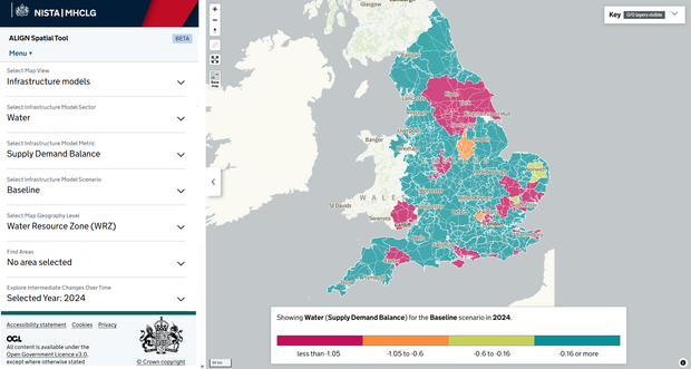
By providing a common spatial evidence base, ALIGN allows users to explore how housing, employment and other growth scenarios interact with infrastructure capacity. For example, if you want to build 10,000 homes and new commercial floorspace in an area, the ALIGN models can tell you how much electricity and water you may need to meet that demand compared to planned capacity. By bringing together data and modelling in one place, it can speed up decision-making and plan-making for both central and local government, in turn helping to unlock and accelerate housing delivery and economic growth.
ALIGN has two primary use cases at different levels of government:
- ALIGN is providing central government with spatial evidence to inform policy development and decision-making. It is also being used to provide a rapid and consistent cross-sector assessment of infrastructure gaps, risks and constraints at locations identified as priorities for significant growth and housing. This will help local partners, government departments and infrastructure providers to develop a shared understanding of where further analysis, options development or coordination may be needed.
- At the local and strategic level, in collaboration with the Digital Planning Programme, ALIGN will help planning authorities to prepare spatial development strategies and local plans. By providing consistent infrastructure capacity metrics for various growth and delivery scenarios, the tool can assess the implications of development choices and infrastructure delivery options at a local level. The tool can reduce reliance on multiple commissioned studies, support planning across administrative boundaries and help authorities develop evidence-based plans more efficiently.
Importantly, ALIGN doesn’t make planning decisions. It provides complementary evidence to local insights and knowledge to help coordinate numerous stakeholders to test options, understand trade-offs and make informed judgements based on local circumstances.
ALIGN complements government’s wider suite of digital planning products and services, including the Planning Data platform, Open Digital Planning and Extract, helping local government self-serve through better use of data and tools to support growth and development.
What’s happening next
Options are currently being considered for a phased rollout of the tool and its data this financial year.
You will be able to find out more information about ALIGN, the data and models it uses at an upcoming webinar later this year. Register your interest if you'd like to be sent more information and be added to the invite.
For more information about the Digital Planning programme, follow us on LinkedIn to stay connected, and subscribe to our newsletter for the latest updates.



1 comment
Comment by Olabisi O Esther posted on
A very good work and with modern infrastructures.